Indian Ocean in World History Overview for Students
Selections from each era
Geographic Features:
Indian Ocean Description
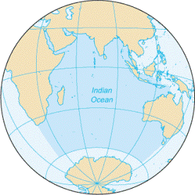 The Indian Ocean covers 68,536,000 square kilometers (26,461,897 square miles) and covers 20% of the world's ocean surface. There are five commonly recognized oceans in the world. Only the Pacific, at 155,600,000 sq km (97,250,000 sq miles), and the Atlantic, covering 82,362,000 sq km (51,476,250 sq miles) are larger.
The shape of the Indian Ocean is like a huge letter 'M.' Its outline extends from the East African coast north to the Arabian Sea, down the western coast of India to Sri Lanka, and up India's eastern coast, where it forms the Bay of Bengal. The eastern arm of the 'M' is formed by the Indochina Peninsula, the Island of Java, and the west coast of Australia. In other words the 'M' covers the area between the Tropic of Cancer in the Northern Hemisphere, past the Tropic of Capricorn in the Southern Hemisphere to the line of 40 degrees south latitude.
According to the International Hydrographic Organization (IHO) and the United Nations Oceans Atlas, the area from 40 degrees S latitude to 60 degrees S latitude is included in the Indian Ocean. The area that encircles the globe from 60 degrees S latitude to the coast of Antarctica is called The Great Southern Ocean. The Indian Ocean's width extends from 45 degrees E longitude to 110 degrees East longitude.
Monsoon Cycle
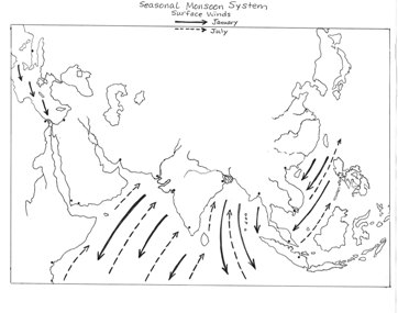 Monsoon is a word meaning season of winds, from the Arabic word mawsim (MAW-sim). The world's largest monsoon system, powered by a seasonal warming and cooling of large air masses, occurs in the Indian Ocean. The wind patterns along the ocean shift direction in winter and summer, blowing from the southwest during half of the year and from the northeast for the other half. The monsoon also brings a dry season and a wet season.
The monsoon cycle is caused by three factors: the difference in the way land and water absorb the sun's heat; the effect of the earth's rotation on the atmosphere; and the storage and release of energy as water changes from liquid to water vapor and back again. The fact that land is hot and oceans are much cooler plays an important role in the development of monsoons. Land absorbs the sun's heat faster than any body of water.
In the summer, air masses over land heat up, expand, and rise. As warm air rises over the land, cool, heavy air full of water vapor from the ocean rushes in to replace it. The ocean air, blocked from moving further into Central Asia by the giant Himalayan Mountains, then releases the water vapor over land, bringing a season of rain. During the summer monsoon, which lasts from about June to September, parts of India receive 70%-90% of their total annual rainfall.
The opposite happens in the winter, however, because during that season the air over land cools more quickly than the ocean. As the ocean air rises, cooler air from the land rushes in to replace it. These northeast winter winds, which lose their moisture over the huge land mass of Asia, are much drier than the summer monsoon winds.
Arabian (Persian) Gulf
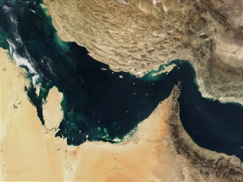 Also known as the Persian Gulf, this body of water was very important to the traders of the Ancient Era. Although it was once a river connected to the Tigris and Euphrates, over a period of 15,000 years the Arabian Gulf gradually widened and deepened until it reached its current size. Melting polar ice caps at the end of the last Ice Age caused flooding that filled the Gulf. By 3000 BCE, it was being used by early traders. The Arabian Gulf was relatively easy to sail without using the monsoon winds, and to navigate without knowledge of the stars. Merchants could travel the Gulf's waters in small boats simply by staying near the coast and always keeping land in sight. This way, sailors could not get lost as would sometimes happen in open seas. They could also stop to pick up supplies or trade with the many settlements along the shores of the Gulf. As a result of its location and relatively calm waters, the Arabian Gulf has been a crucial part of the world's trading network since the very beginning of commerce and urban civilization.
Strait of Hormuz
At the entry to the Arabian (Persian) Gulf, a narrow outlet only 48 kilometers (30 miles) wide leads to the Gulf of Oman and the Arabian Sea. Known as the Strait of Hormuz, it has an even narrower channel near the middle through which deep-water ships can pass. To its north, the Arabian (Persian) Gulf extends northwest about 965 kilometers to the Shatt al Arab, a river formed where the Tigris and Euphrates Rivers join together.
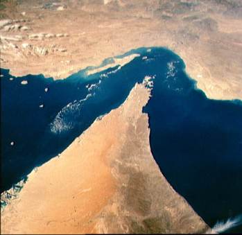 About 20,000 years ago or more, when human beings migrated across the southern coast of the Arabian Peninsula into Southwest Asia, the Arabian (Persian) Gulf was not a sea. It was instead a shallow river valley almost 1,000 kilometers long. The ancient Tigris-Euphrates River flowed through the valley as one river. When sea levels rose as a result of melting polar ice caps at the end of the last Ice Age, the valley began to change into a shallow gulf. The Strait of Hormuz is now the only outlet for the salty water of the gulf to be gradually replaced by Indian Ocean water. Since it reached its current form about 5,000 Before Present (BP), the Strait of Hormuz has also been the only outlet for ships to reach the Arabian Sea and the Indian Ocean beyond. By that time, people had settled along the shores of the gulf, establishing societies that traded the wealth of its waters and the surrounding land with those on the shores beyond the Strait of Hormuz.
Ancient Era, 5000-1000 BCE
Magan
Magan, located in what today is known as Oman, is the ancient name for a region linked by trade with Mesopotamia and the Indus Valley. Sumerian and Akkadian texts from around 2300 BCE mention trade by sea with Magan, which was especially rich in timber, copper, and the stone diorite. All of these materials were very important for building, art, and making everyday utensils such as pots, and were highly sought after by the rich and powerful kings of Mesopotamia. The image below shows the site of an ancient Magan copper mine.
Magan was also an important trading stop on the way from Mesopotamia to Meluhha, or the Indus Valley. Ships from Magan, Meluhha, and the port of Dilmun carried items like wood, copper, carnelian, onions, and spices, trading them for Mesopotamian products such as wool, grain, paint, leather, and oil. From roughly 2800-1800 BCE Magan was a very prosperous region, connected with and important to the other major civilizations of the period.
Magan Boat
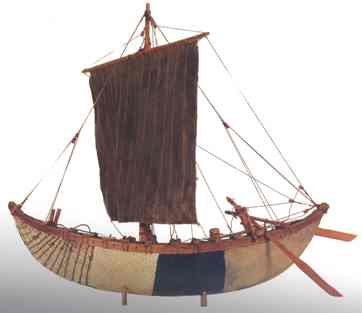
From around the 3rd millennium BCE, a type of boat called a magan was made with reeds, coated with bitumen and clay, and fitted with a mast and a square sail and steering oars was used for trading in the Arabian (Persian) Gulf and beyond. The image shows a replica model in the Maritime Hall of the Museum of the Frankincense Land in Oman.
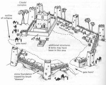
Beehive Tombs and Circular Towers of Bat
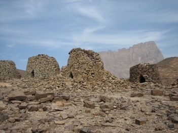
Near the present-day town of Bat, archaeologists have found well-preserved cemeteries that contain Bronze Age 'beehive' shaped tombs like those shown in the first image. They have also found the remains of towers, as shown in the diagram below, that they believe are evidence of a thriving settlement during the 3rd millennium BCE.
Tombs found in the hills and high valleys north of Bat show ongoing development during the Bronze Age. The northernmost tombs date from 3000-2600 BCE and are simpler than those appearing further south and dating from 2600-2000 BCE. The earlier tombs' distinctive 'beehive' shape can be seen dotting the landscape in this region, indicating a series of oasis towns. These towns may have acted as key points in the copper trade along the route across the Arabian Peninsula. They have also found the remains of towers that they believe are evidence of a thriving settlement during the 3rd millennium BCE.
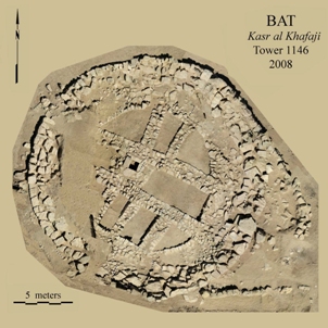
The circular tower structures in the second image date to the 3rd millennium BCE in Oman. It is not clear how they were used by people living in the settlement. An unusual and mysterious feature of these towers is an inner circular wall in one of the towers, which is not found in any other place. Trenches connected to these towers could mean that they were part of an irrigation or well system. Future excavations of this Bronze Age settlement at Bat will hopefully bring greater understanding of the agricultural and possibly trade activity that took place there.
Copper
 Metals such as copper were very important to ancient civilizations, allowing them to make tools, weapons, utensils, sculptures, and jewelry. Copper was widely used in cities in ancient Mesopotamia and Iran, where craftsmen mixed it with other materials such as arsenic, which made it harder and more durable. As early as around 2750 BCE, archeological evidence shows that these regions began to import their copper from Oman, which had large natural deposits of the metal. Ancient texts from Sumer in Southern Mesopotamia mention Magan, which most historians believe to be the ancient name of Oman, as a major source of copper. Bahrain, called Dilmun in Mesopotamian texts, served as the main port through which Omani copper was traded.
Classical Era, 1500BCE – 300CE
The Lost Caravan City of Ubar
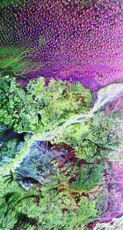 The image is an infrared picture of the land surface in the southern part of Oman on the Arabian Peninsula. It was taken from the NASA Space Shuttle Endeavor in 1994. The purple, green and magenta colors are added by computer to make it easier to see what the image reveals. The magenta area shows huge sand dunes. The green areas are limestone rock on the surface. The white stripe is a dry stream bed. Near the center of the image is a place archaeologists and historians have been seeking for many years - a lost caravan city called Ubar.
The satellite imaging helped locate a likely site for the city because the infrared image detected ancient caravan routes made by the movement of hundreds or even thousands of camels and people at a time, traveling in caravans over hundreds of years. The caravans wore tracks in the desert, just as feet in a busy building wear tracks in the carpet. The site was found where several routes all came together. Scientists believe this is where the city must have been. A team of archaeologists used the Global Positioning System to find the spot in the desert of Oman matching the satellite imaging. Around the site they found pieces of pottery and some other artifacts. The main finds at the site, however, were the remains of walls and towers from a large fortress. The walls had partly collapsed into a deep hole, which can be seen in the aerial image taken of the site. The blue lines are reconstructions of the ancient walls.
What destroyed the city? The area had many limestone deposits, which the builders of the ancient city had used for the walls and towers. The caravan city had a good supply of water under it, with wells, fruit trees and gardens. Limestone formations often hold underground springs and reservoirs. Water seeps underground over millennia, dissolving the limestone and forming caverns. The danger of living on limestone formations, however, is collapse. These limestone formations form sinkholes that swallow whatever is above them. The archaeologists found the collapsed walls in the depression formed by the sinkhole, which must have been deeper long ago. With the sudden collapse of the city, it would have been abandoned by anyone surviving such a catastrophe.
 Ubar is a site that historians believe may be a city mentioned in the scriptures, or holy book of Islam, the Qur'an. It was described there as a wealthy city with towers, but one that became a ruin and was lost. Ubar's wealth came from its position on the incense trade routes, not far from what was then a large area where frankincense trees produced their fragrant, dried sap. This incense was prized in India, in the Mediterranean region, and in east Africa for its wonderful smell. It was in high demand for use in temples, as medicine, and in perfumes. Ubar is believed to have thrived as a center for incense transport and sale from around 2800 BCE to 300 CE. The incense trade began as early as 5000 BCE by sea and land from this hub in Oman on the southern Arabian Peninsula.
Kamal - Key Navigational Tool
 The kamal is a simple navigation device used by Arab navigators in the Indian Ocean since ancient times. It consists of a small, rectangular card with a knotted cord passed through it. The purpose of the kamal was to determine latitude at sea by observing the distance between the horizon and a particular star at the same time each night. An alternative--or the original--method for the same purpose involved the use of fingers held parallel to the horizon. The concept is that these reference stars, observed at their highest point in the night sky, would always appear the same distance from the horizon if the position of the ship was at a certain latitude. At a higher or lower latitude (that is, closer to or farther from the equator) the distance would be greater or less. A navigator would hold the card at a measured distance from his face by means of a series of knots in the cord attached to the card. The cord would be held in the teeth. The card would appear smaller or larger depending on how far from his eye level it was. The kamal, or measurement with the fingers, was especially well suited to crossing the Indian Ocean on the monsoon winds, since they blow in a steady easterly or westerly direction during each of the two seasons for going out and returning. The pilot's job was to aim for a certain latitude where he knew that the port city lies. In this way, the knots on the cord would represent the latitude needed to reach a series of specific places.
Frankincense and Myrrh
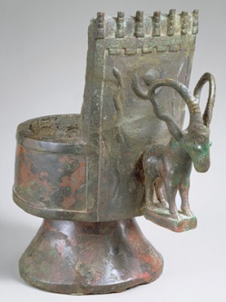 This bronze container from Southwestern Arabia was used for burning incense. It is decorated with a crescent moon, snakes, and a type of wild mountain goat called an ibex, all symbols of ancient South Arabian gods. Frankincense and myrrh, both types of incense that release a pleasing aroma when burned, were an important part of religious rituals in cultures across the Arabian Peninsula, the Mediterranean and the Near East. They were also used as an insect repellant, as medicine, and for embalming ancient Egyptian mummies.
Frankincense and myrrh are the dried sap of trees that grow exclusively in Southern Arabia, Ethiopia, and Somalia. During the Classical Era, they were transported by Arab merchants-along with spices, gold, ivory, pearls, precious stones and textiles-through the deserts of the Arabian Peninsula using camel caravans. This trade route, known as the Incense Road, went as far north as the Mediterranean port city of Gaza. From there, frankincense and myrrh were shipped across the Roman Empire and to Asia. The abundance of such an expensive and valuable trade good in southern Arabia led many to believe that this land was fabulously wealthy. As a result, the region became known as Arabia Felix, meaning "Arabia the Blessed," or "Happy Arabia."
Scylax of Caryanda
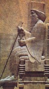
Scylax of Caryanda made a voyage into the Indian Ocean from 510-515 BCE. He went exploring in the service of King Darius of Persia (528-468 BCE), who had heard of the riches of India and wanted to discover the mouth of the Indus River. The image shows Darius in a carved relief. He traveled overland in the company of some Greeks, and entered the Indus River several hundred miles from its mouth, in today's Pakistan. He sailed downstream to the Indus mouth, and into the Arabian Sea. He sailed along the shore toward the west, followed it to the mouth, and then sailed along the shore westwards. Scylax reached Harmozeia in the Arabian (Persian) Gulf near the Straits of Hormuz, and then crossed over to Oman, near Maka, and sailed along the southern shore of the Arabian Peninsula. He stopped at the Yemeni ports, and then sailed up the Red Sea to the Suez. At the time, Egypt was under Persian control, so it was friendly territory for Scylax. He was famous for this voyage, and brought news of these regions that encouraged trade expeditions. Scylax later wrote a handbook for mariners, and was mentioned by Herodotus the Greek historian.
Periplus of the Erythraean Sea
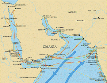
"Sailing through the mouth of the Gulf, after a six-days' course there is another market-town of Persia called Ommana. To both of these market-towns large vessels are regularly sent from Barygaza, loaded with copper and sandalwood and timbers of teakwood and logs of blackwood and ebony. To Ommana frankincense is also brought from Cana, and from Ommana to Arabia boats sewed together after the fashion of the place; these are known as madarata. From each of these market-towns, there are exported to Barygaza and also to Arabia, many pearls, but inferior to those of lndia; purple, clothing after the fashion of the place, wine, a great quantity of dates, gold ..."
This quote is taken from Chapter 36 of Periplus of the Erythraean Sea, a trader's handbook written around 70 CE. Periplus, or "sailing around," was written in Greek by an Egyptian merchant from the city of Alexandria. The document gives a detailed account of trade between Roman Egypt and India, listing all the ports on the Red Sea, the African coast, and the Arabian Peninsula. Chapter 36 mentions the port cities of Ommana, located in the present-day United Arab Emirates, Cana, now known as Bir Ali in Yemen, and Barygaza in India.
Periplus also describes the people who lived in these various seaports, styles of boats used by sailors, and the items imported and exported. Trade goods like copper, wood, pearls, cloth and gold were regularly exchanged, as was frankincense, a highly prized good native to the Arabian Peninsula. The clear and thorough writings in Periplus paint an accurate picture of Indian Ocean trading systems in the first century CE.
Natural History by Pliny the Elder
"Next in affinity to cardamomum would have been cinnamomum, and this we should have now proceeded to speak of, were it not more convenient first to make mention of the treasures of Arabia, and the reasons for which that country has received the names of "Happy" and "Blest." The chief productions of Arabia are frankincense and myrrh, which last it bears in common with the country of the Troglodytoe. There is no country in the world that produces frankincense except Arabia, and, indeed, not the whole of that."
This text is from the famous encyclopedia Natural History, written by Roman author and naturalist Pliny the Elder around 77 CE. It provides evidence of trade between the Roman Empire and the Arabian Peninsula, the native land of frankincense and myrrh-producing trees. While Pliny mentions spices like cardamom and cinnamon, he thinks it more important to first discuss frankincense and myrrh, both highly prized trade goods at the time. Arabia's precious trees earned it the nickname Arabia Felix, or Happy Arabia, and allowed it to dominate the Incense Road, a trade route that stretched through the peninsula to Rome and Asia. Pliny also mentions the land of Troglodytoe, or present-day Ethiopia, which like Arabia grew and exported incense. Natural History is one of the most detailed Roman works ever produced, and continued to be a major guide for scientists until the Middle Ages.
Medieval Era, 300-1500 CE
Sohar
 The coastal city of Sohar in today's Oman is so closely associated with trade in the Indian Ocean and seafaring that it is mentioned as the birthplace of Sindbad the Sailor. Whether Sindbad was a real person or not, the character from Thousand and One Arabian Nights is a symbol of the wealth and adventure of Muslim trade during the Abbasid dynasty.
The places described in the Sindbad stories are real places and the products such as jewels that Sindbad won during his adventures were real. Only the stories attached to them were fantasy. Sohar was an important port on the Strait of Hormuz that was described in the work of Muslim historians and geographers and many travelers. The geographer-historian Yaqut al Hamawi stated that Sohar was named after a descendant of Prophet Noah, given to the place in the 6th century CE. The Muslim geographer Muqadisi described the city during his visit in the 10th century CE as 'flourishing city with a large number of people living there. It is a beautiful city with a comfortable life...and its mosque overlooks the sea...the Mihrab (indicator of the direction for prayers) changes colour because it is covered in copper...'
Al Istakhri wrote: 'Sohar, the heart of Oman, lives on the sea coast and it is rich with shops where ships anchor. It is the oldest city in Oman and the most wealthy one. There is no prosperous and developed city on the Persian Sea and Muslim countries other than Sohar.'
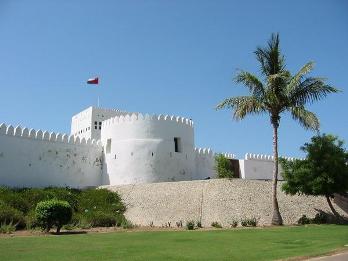
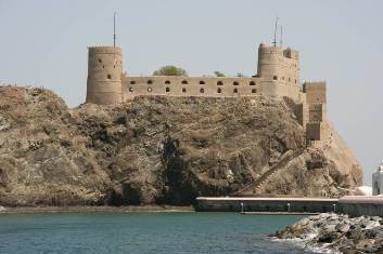
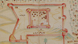 Sohar was also a source of copper, and the fact that it has a good harbor and strategic location made it a prosperous place between the 8th and the 15th centuries. Settlement of the site goes back much further, and many archaeological sites reveal evidence of trade from ancient times through the Islamic period. The city was famous as a port with homes and palaces and mosques. The merchants of the city had connections with Africa, India, and China. Sohar Castle, shown in the photo and diagram, was built during the 13th and 14th centuries CE by the rulers of Hormuz and it played a role in struggles with the Portuguese during the 15th century. In keeping with the voyages of Sindbad, a reconstructed Arab dhow was built in Oman in 1980 and named The Sohar. The Sohar, as seen on the introductory video, made a voyage from Oman to China.
Arab Dhow
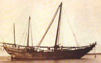
The dhow was the most typical ship of the Western Indian Ocean, and the one most commonly used by Arab traders during the medieval era. There are various sizes of dhows, each called by a different name in the region. The description here tells what these ships mostly had in common.
First, the dhow is known for its triangular sail. Many dhows had one large sail, but other types had more than one mast and sail. It is difficult to know when they were first built, but several characteristics go back to the earliest technologies of sailing in the Indian Ocean. Dhows were made of tropical woods such as teak, which grows in India, and does not rot easily in salt water. Teak was hewn with an ax into planks, which were drilled with holes on both sides. The most unusual characteristic of dhows is that
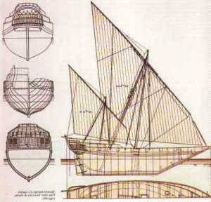
they were not nailed together. Instead, they were sewn, or lashed together with coir (coconut fiber) ropes. This tradition lasted for many, many centuries because a sewn ship was flexible and the rope lashing lasted much longer than iron nails, which rusted and needed to be replaced. A lashed ship would not break up easily on shoals (shallow stretches of water or sandbars), but would flex under the strain.
Another characteristic of dhows was that the planks were laid side-by-side and did not overlap like the shingles of a roof. This required less wood, and also presented a smooth surface to the water. Between the planks, caulking made from coir, gum, and other substances was pounded in to make it watertight. The planks were oiled regularly inside and out, to preserve the wood. The dhow was double-ended, instead of having a square stern and a pointed bow.
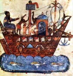
From approximately the 11th century on, the angle of the stern changed as the sternpost-rudder replaced the steering oars of earlier ships. This book illustration of a dhow from the 13th century shows the stern-rudder clearly. The ribs that strengthened the hull of the dhow were constructed inside the planks as it was built, and lashed to it. The dhow often had a single mast, with a long beam on which the longest side of the triangular sail was lashed. The mast was attached to the ship with rigging on either side, and the beam could turn the sail from side to side, as the dhow was very agile in various winds. A square-sailed ship could only make headway with the wind behind it, but a lateen (triangular) sailed ship could tack in a zig-zag pattern close to the wind. Dhows are still in use today for coastal trading around the Western Indian Ocean rim, and historic reconstructions of these famous ships are also still popular in Arab seacoast countries.
Ibn Batutta
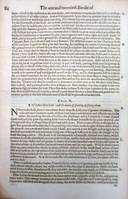
'From Kilwa we sailed to Dhofar...[near the Yemeni border with Oman]. Thoroughbred horses are exported from here to India...a month's journey with a favoring wind...The inhabitants cultivate millet and irrigate it from very deep wells, the water from which is raised in a large bucket drawn up by a number of ropes attached to the waists of slaves. Their principal food is rice imported from India. Its population consists of merchants who live entirely on trade. When a vessel arrives they take the master, captain and writer in procession to the sultan's palace and entertain the entire ship's company for three days in order to gain the goodwill of the shipmasters...In the neighborhood of the town there are orchards with many banana trees. The bananas are of immense size; one which was weighed in my presence scaled twelve ounces and was pleasant to the taste and very sweet. They grow also betel-trees and coco-palms, which are found only in India and the town of Dhafari...The coco-palm is one of the strangest of trees, and looks exactly like a date-palm. The nut resembles a man's head, for it has marks like eyes and a mouth, and the contents, when it is green, are like the brain. It has fibre like hair, out of which they make ropes, which they use instead of nails to bind their ships together and also as cables...They use [its oil] for lighting and dip bread in it, and the women put it on their hair....We then set out for Oman and arrived there after six days' traveling. It is a fertile land, with streams trees, orchards, palm gardens, and fruit trees of various kinds. Its capital, the town of Nazwa, lies at the foot of a mountain and has fine bazaars and splendid clean mosques. Its inhabitants make a habit of eating meals in the courts of the mosques, every person bringing what he has, and all sitting down to the meal together, and travelers join in with them. They are very warlike and brave, always fighting between themselves. The sultan of Oman is an Arab of the tribe of Azd, and is called Abu Muhammad, which is the title given to every sultan who governs Oman. The towns on the coast are for the most part under the government of Hormuz.'
Ibn Battuta continued on into the Arabian (Persian) Gulf, and on to Makka for another pilgrimage journey, probably in the year 1333 CE.
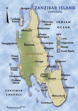
The Island of Zanzibar
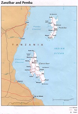
Zanzibar is an island in the Indian Ocean about 30 km (20 miles) off the East African coast, just south of the equator. Pemba is a nearby island to the northeast, and there are several smaller islands that belong to the Zanzibar Archipelago (island group). Zanzibar is a large coral island about 1,660 sq km (640 sq miles) in size. Its climate is affected by the monsoon cycle of rains and winds, so it has abundant rain during part of the year.
The island was originally covered by tropical forests, and has some rare animals. Zanzibar may have been settled as early as 4000 BCE by fishing folk from mainland Africa. By 1000 BCE it had been discovered by traders, and was known to the Romans and Greeks. By the 3rd century CE, traders from Southern Arabia and the Arabian (Persian) Gulf visited regularly, and Zanzibar may have gotten its name from Persian. From the 6th to the 15th centuries, Zanzibar was part of the East African trade system controlled by Arabs, who intermarried with local people and spread the Arabic language. Kiswahili has its origins in the local language from the Bantu group of African languages, combined with Arabic.
First Global Era, 1400-1800 CE
Muscat, Sultanate of Oman
The port city of Muscat, which had been a center of trade since the 6th century BCE, played an important role between 1500 and 1800. The Portuguese recognized Muscat's strategic position near the chokepoint of trade from the Arabian (Persian) Gulf, which linked the Indian Ocean to the Eastern Mediterranean via overland caravan routes. Their strategy for opening the trade routes to India meant shutting down those of both Christian and Muslim rivals. Muscat became a target, and in 1507 Portuguese vessels under the command of Alfonso de Albuquerque invaded the Gulf of Oman. They faced the forces of Muscat's Persian governor in a bloody battle. The Portuguese sacked and occupied Muscat, killing civilian residents and pillaging the city.
In 1514, the Portuguese completed their control of the chokepoint by taking the strategic island of Hormuz, where they built a fort protected by cannon and a permanent troop presence. They strengthened Muscat's fortifications, building a stone fortress on high ground, with strong towers. In spite of aid from the Persians and an expedition by the Ottoman navy in 1546, Portuguese control of Muscat lasted for more than a century.
In 1624, a new group under Imam Nasir al Yaribi was elected to power in Oman. The new ruler sent a force to Muscat in 1648 to challenge the Portuguese. They captured the Portuguese fortress and destroyed the towers that commanded the town. In 1650, the son of the Imam, Saif bin Sultan, led the forces in a night attack that defeated the Portuguese and returned Muscat to Omani control.
After this victory, the Omani forces expanded their position on the east African coast at the expense of the Portuguese and in spite of other rising European groups. In 1698, Saif bin Sultan, son of Nasir, took the Portuguese garrison of Fort Jesus in Mombasa and expelled them from the rest of the coast to Mozambique. They pushed the Portuguese out of Zanzibar and set up their own rule there, establishing an Omani empire in the region. In 1749, the Abu Sa'id Dynasty was established and continues to rule Oman to this day.
Ahmad Ibn Majid
'It is sensible that every man knows his own coast best, although God is all-knowing, and it is certain that (local residents)..live nearer to these coasts than anyone else, so we have used them and their navigational charts as a guide'.
Ahmad ibn Majid was born in Oman in 1432 and spent his life sailing around the coasts of Africa and Asia and writing about the Indian Ocean. In 1490, he wrote his most important book, The Book of Useful Information of the Principles and Rules of Navigation. It included information on wind and monsoon patterns, locations of port cities from East Africa to Indonesia, the differences between open sea and coastal sailing, and the art of navigating by the stars. In all, he wrote over 40 books.
Ibn Majid recognized that 'every man knows his own coast best' and relied on local knowledge to compose navigational charts throughout the Indian Ocean area. The above account was written somewhere in the Bay of Bengal and his other writings on the region were based on the accounts of local sailors.
Historians dispute whether Ahmad ibn Majid was the pilot on Vasco da Gama's historic voyage to India. Nonetheless, written accounts exist where local Arab and Indian sailors were frequently consulted and often piloted early Portuguese and other European voyages because of their knowledge of Indian Ocean sailing conditions.
Industrial and Imperial Era, 1750-1920
Muscat
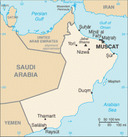
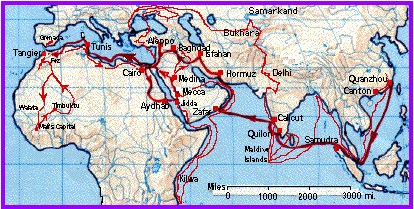
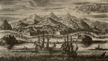
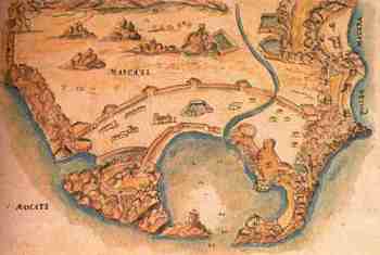
The map shows the port city of Muscat in northeast Oman. In the 19th century, this maritime port was viewed as the busiest port of the entire Arabian peninsula. The photo below shows the Muscat harbor in the 1800's. An international port, the city was densely populated, multi-religious, and multi-ethnic. Muscat was one of three important trading centers that reflected Omani interests in the region. Muscat acted as the crossroads of trade between East Africa, the eastern shores of the Gulf, and western India. In the 19th century every kind of merchandise could be found, silk and linen, spices, dates, coffee brought across the desert by caravans, pearls, grapes, bananas, figs, butter, fowl, and the list goes on. The city was central to the rise of Zanzibar's economic success, acting as a main station for the import and export of items from Zanzibar.
Muscat was known for being supreme in trade and military power, and the city produced a lot of wealth for the Omani nation. Omani rulers carried out careful relationships with traditional Indian Ocean trading partners and with the European powers, and even concluded a trade treaty with the Americans in 1833.
Sultan of Muscat – USA Friendship Treaty, 1833
'The long established and increasing trade of the United States in the Indian Ocean, and particularly with Maskat, Zanzibar and the Persian Gulf has lately attracted public attention both in India and England, from the fact that American cottons are silently making their way not only into all parts of Central Africa but also into India itself. The following treaty between the United States and the Sultan of Maskat was negotiated by Mr. Edward Roberts of Portsmouth, N. H., in the year 1833.'
...Article 1. There shall be a perpetual Peace between the United States of America and Seyed Syeed bin Sultan and his dependencies. The Citizens of the United States shall have free liberty to enter all the Ports of His Majesty Seyed Syeed bin Sultan, with their Cargoes of whatever kind the said cargoes may consist, & they shall have the liberty to sell the same, to any of the subjects of the Sultan, or others who may wish to buy the same, or to barter the same for any produce or manufacture of the Kingdom, or other articles that may be found there--no price shall be fixed by the Sultan or his Officers on the articles to be sold by the Merchants of the United States, or the merchandise they may wish to purchase--but the trade shall be free on both sides, to sell, or buy, or exchange on the terms, & for the prices the owners may think.'
In 1840 the ship Sultana, in order to further develop relations between the Omani empire and the United States, was sent by Sayyid Said bin Sultan al Busaid to deliver merchandise and gifts for President Martin Van Buren. This voyage took place seven years after the first American-Omani Treaty of Friendship was agreed on in Muscat in 1833. Parts of the treaty are quoted above. The treaty gave Americans economic and judicial privileges within the Arab and African states of the Sultan, and was the first joint agreement between the US and an Arab Gulf state. The mere existence of the treaty was a sign of a new era in international relations.
Occasional commercial contact between the US and Oman began in the late 1700s. Muscat's importance as a transit port for Arabian (Persian) Gulf commerce was ideal for American coastal trade. The Omani-American commercial agreement resulted in the growth of American trade throughout the African states of Oman as well. The number of American ships docking in Zanzibar increased rapidly because the ships were importing, amongst other goods, an American strong cotton fabric which became very popular in East Africa, the Gulf and Arabian Peninsula. Americans also traded with Zanzibar for cloves, ivory, gum copal, copra, and spices. Oman was the first country in the Arabian Peninsula and gulf region to establish friendly trade relations with the US and a US consulate was established from 1880 until 1915.
Zanzibar
In the 17th century, Zanzibar came under the control of the Sultanate of Oman, which developed an economy of trade and cash crops, ruled by Arab notables. The Portuguese, who earlier had a foothold in Zanzibar, were gradually expelled and a prosperous trade in slaves and ivory thrived. The trade in cloves, grown on plantations, added to Zanzibar's growing place in the powerful trade network dominated by the Omani Arabs during the first half of the 19th century. Omani Arabs established trading posts at Zanzibar, Pemba, and Kilwa, and the rich coastal trade of the Western Indian Ocean involved all kinds of high-value merchandise and spices. Omani participation in Indian Ocean trade gave rise to a commercial dynasty. The dynasty was very dependent on international trade and became a dominant power in the Western Indian Ocean. The second image shows a port city of Zanzibar in the 19th century.
In the 19th century the main exports from coastal East Africa and the island of Zanzibar were: cloves, copal, ivory, leather and skins, red pepper, sesame, copra, coco oil, tortoise and cowry shells, beeswax, tallow and all kinds of objects. Arab sailors from Red Sea carried aloe and coffee, while those sailing from the southern coast of Arabia sold dried fish, fish oil, ghee, and onions. Ships from Oman and the Arabian (Persian) Gulf to Africa carried dates and raisins, donkeys and horses, cloth from Muscat, Persian carpets and silks, almonds and spices.
The British Empire gradually took over Zanzibar, and their relationship was made formal with the 1890 Heligoland-Zanzibar Treaty. This treaty made Zanzibar and Pemba a British protectorate. The British ruled through a sultan (vizier) from 1913 until Zanzibar received its independence in 1963.
20th Century and Modernization, 1920-present
Sultan Qaboos Grand Mosque Carpet and Chandelier
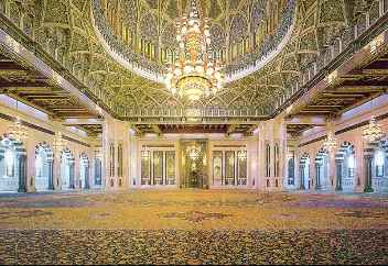 In 1992, His Majesty Sultan Qaboos bin Said proposed that the Sultanate of the Oman build a grand mosque. After a design competition to choose an architect, construction on the site began in 1995. On May 4, 2001, the Sultan led prayers for the inauguration of the Grand Mosque, named in his honor. It is the largest, and many people think, most beautiful building in the Sultanate of Oman. Not only does it serve as a place of worship, but it also serves as an educational center.
The carpet shown in the image is from the Sultan Qaboos Grand Mosque and is one of the largest hand-woven carpets in the world. It measures 70 x 60 meters, covering the Mosque's 4343 square meter main prayer hall. Combining the classical Tabriz, Kashan and Isfahan traditions, it contains 1,700 million knots and weighs 21 tons. The Diwan of the Royal Court of the Sultanate of Oman ordered the carpet from the Iran Carpet Company, and it took four years to produce.
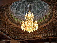 The Sultan Qaboos Grand Mosque is also decorated and illuminated by one of the world's largest chandeliers. It weighs an estimated 8.5 tons, more than the weight of a minke whale. About 46 feet tall (as much as a four story building), it is 26 feet in diameter. Since the ceiling of the Grand Mosque is 150 feet high, with an 80-foot dome, the chandelier's size fits the space very well, and it is the most efficient way of lighting such a large space. The light from this chandelier comes from 1,114 halogen, or mercury vapor, bulbs. All of the metal parts of the crystal chandelier are plated with 24-carat gold.
Tim Severin
Tim Severin is a British explorer, author and film maker fascinated by legendary journeys of the past. Severin builds ancient style ships using traditional methods and materials. Then he sails them, following the routes of famous seafarers like Saint Brendan the Navigator, Ulysses, and Jason and the Argonauts. His purpose is see if their voyages were actually possible in such ships, and if real places might have provided the inspiration for any of their adventures.
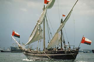 One journey was inspired by the story of Sinbad the Sailor. For the trip, Severin and a crew of 25 sailed a traditionally built dhow called the Sohar from Muscat, Oman to China. The project was sponsored by the government of the Sultanate of Oman. With the help of Omani shipwrights, Severin built an 80-foot long ship as a faithful copy of early Omani ships. The wood they used was hand hewn and sewn together using coconut rope. The inside of the hull was soaked with coconut oil to preserve the stitching, and the outside was smeared with mutton fat and lime to protect it from being eaten by marine worms. There was no engine. Instead Sohar was propelled over the sea by triangular cotton sails. All their meals were cooked on the deck with charcoal. On his voyage Tim Severin tested the ancient Arab way of navigation using the stars and an ancient Arab instrument called a kamal. The voyage took seven months to complete. The journey ended in the famous medieval port of Guangzho (Canton), China, the destination of the actual Sindbad and many real Arab dhows during that time. They were met by Chinese officials and a festive parade.
Desalination
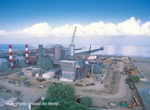
These pictures show how the desalination system works at al Ghubrah, Oman. Desalination is a process that is becoming more and more important in the Middle East and the world, as fresh water resources become more scarce, and human population grows.
Desalination is the process that removes salt from sea-water, providing fresh water for agriculture, drinking, and cleaning. This process works through Reverse Osmosis, a method in which saltwater is pumped through filters and screens that separate the salt from the water. The water that flows out through the machines shown can be further purified and sent to homes, farms, industries, and public buildings.
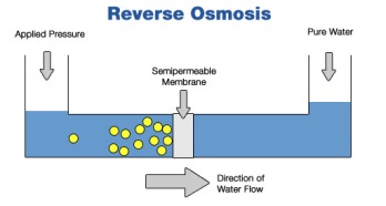
Another process called distillation can also be used to separate salt from sea-water, but it requires a lot of energy. In this process, sea-water is heated in a tank until it evaporates, leaving the salt behind to be physically removed from the tank. Then the water vapor is cooled until it returns to the liquid state and can be piped from the tank for use.
Desalination is an increasingly significant process, especially in the Indian Ocean region. The dry and arid land of the region often lacks sufficient water supplies to fulfill domestic and agricultural needs. Desalination allows governments to take saltwater from the Indian Ocean and make it useable for every day life and agriculture.
Majlis al Jinn
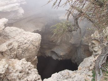 Majlis al Jinn, located in Oman, is the second largest network of caves in the world. The name in Arabic means 'Assembly of the Jinn.' Jinn(djinn) are spirit creatures who are believed to exist in a society parallel to that of humans.
The initial drop into the cave is over 150 meters, and can only be accomplished by highly experienced rock climbers and spelunkers, or cave explorers, since they must climb up ropes or rocks to get back out of the cave. Majlis al Jinn is a significant location in Oman partially due to the tourism it attracts to Oman and also for its abundance of limestone as raw material for export. Full of orange and white stalactites and stalagmites made of limestone, Majlis al Jinn is hundreds of thousands of years old. The cave is five kilometers long and contains deep pools of water at its lowest depths, where blind fish evolved due to the lack of sunlight penetrating into the waters.
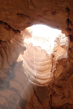 The caves of Majlis al Jinn have so few openings that only a limited number of people may enter at a time. If too many people enter, then carbon-dioxide build-up will suffocate them. This site is becoming increasingly important to Oman's economy for two reasons. First, the limestone in the caves may become a significant resource for the area, as oil resources dwindle. Secondly, the caves' wonders have attracted many geologists, explorers and tourists to the Indian Ocean region. Nature exploration and tourism are growing sources of revenue for the Indian Ocean region, and Majlis al Jinn still attracts people from all over the world. Transport and communication advances of the 20th century have made tourism a more reliable source of income than ever before.
UNESCO and the World Heritage Program
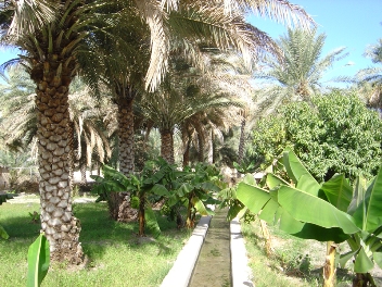
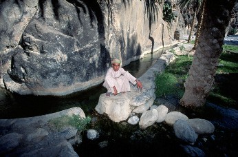 The first two pictures show the aflaj irrigation systems of Oman, named a World Heritage site by the United Nations Educational Scientific and Cultural Organization (UNESCO) in 2006. The aflaj irrigation systems may have existed since 2500 BC. This system evenly redirects naturally flowing water from a series of underground wells in Oman to local springs throughout the country. Farmers and other civilians may then access the water at these springs and utilize it for agriculture or domestic use. The systems were originally intended to provide a fair distribution of water to people in many villages and towns. The word aflaj (singular: falaj) derives from the Arabic root for the verb which means 'to split'.
 UNESCO decided in 2006 that these irrigation systems - still functioning in modern day Oman - reflect both a culture of sustainability and also effective management and resource sharing. UNESCO's World Heritage program began in 1972 and aims to recognize and preserve cultural and natural diversity around the world. This program seeks places that demonstrate unique features of culture and learning that should be preserved so that they remain safe from destruction and can benefit future generations.
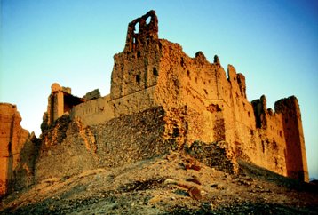
The UNESCO World Heritage list contains natural sites (such as forests, marshes and landscapes), ancient buildings (for example, the ancient Pyramids of Egypt and the Bahla Fort in Oman, shown here), and even entire historical cities (such as the Madina of Fez, Morocco and the harbor of the Strait of Malacca). Over 800 sites are protected through the UNESCO World Heritage Program.
Download the Indian Ocean in world History Overview NOW!